What we do?
In addition to concrete scanning and utility locates, Scantec GPR Services Inc. provides a broad range of specialized GPR services, including underground storage tank (UST) searches, foundation and footing mapping, and infrastructure validation for existing facilities.
Our capabilities also extend to bridge deck corrosion mapping, rebar cover depth measurement, and the detection of sinkholes, voids, and subsurface anomalies. These services support asset condition assessment, rehabilitation planning, and risk mitigation by delivering accurate, non-destructive insight into both shallow and deeper subsurface conditions.

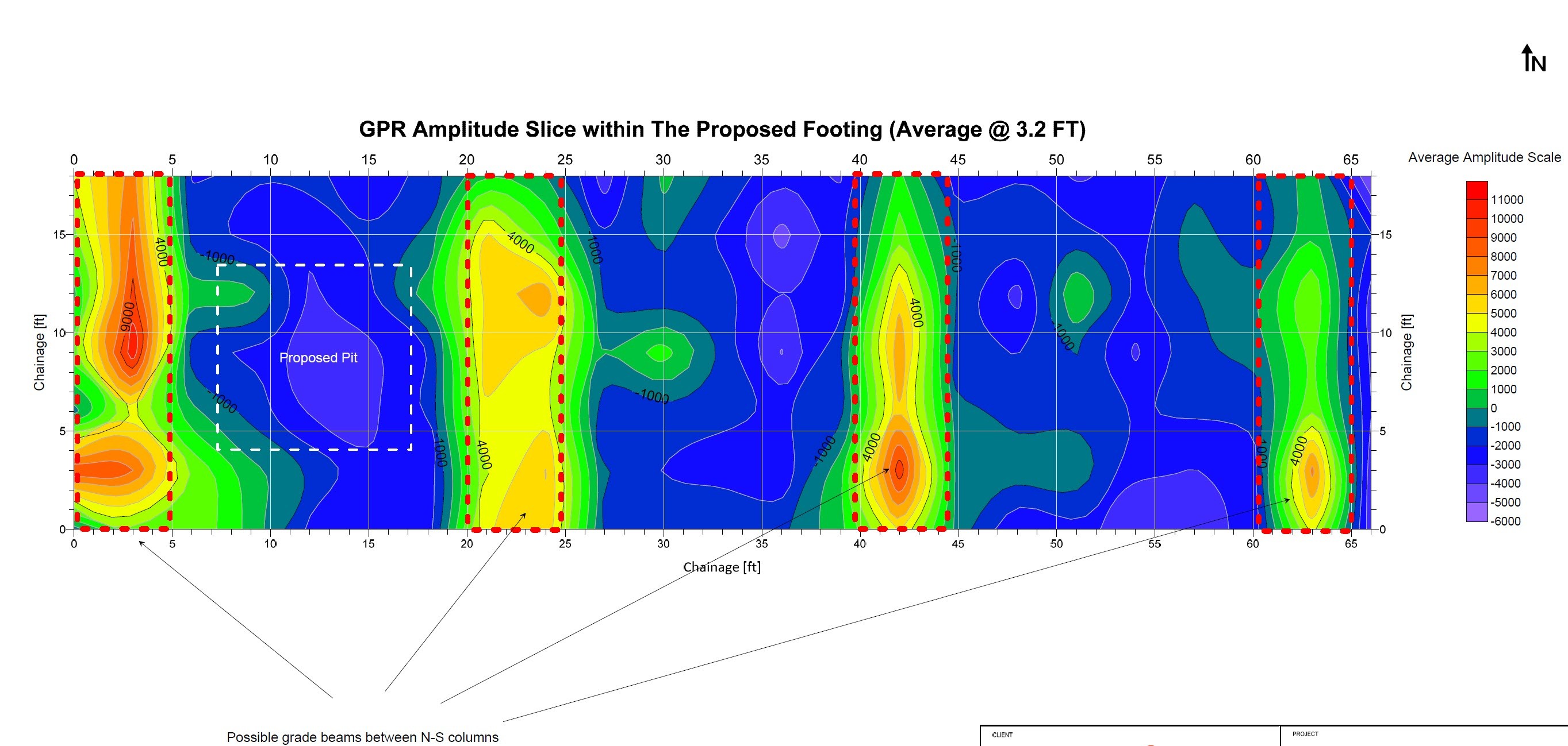
Potential Voids Detection
Scantec GPR Services Inc. provides potential void detection using Ground Penetrating Radar (GPR) to identify hidden subsurface anomalies beneath concrete slabs, pavements, and other structures. By analyzing changes in radar signal response and material properties, our surveys help detect voids, loss of support, washouts, and subsurface weaknesses that may compromise structural integrity. This non-destructive approach supports proactive maintenance, risk mitigation, and informed decision-making before failures or costly repairs occur.

Ice and Muskeg Mapping
Scantec GPR Services Inc. has also completed muskeg mapping and ice road assessment projects using Ground Penetrating Radar. Our GPR surveys help evaluate peat thickness, subsurface layering in muskeg terrain, supporting informed access road planning and ground improvement strategies. For winter operations, we perform ice road mapping to assess ice thickness, continuity, and potential hazards, helping ensure safe transportation and reliable access for equipment and personnel in cold-region environments.

Ultrasound slab thickness estimation and voids detection
Scantec GPR Services Inc. also provides ultrasound slab thickness estimation and void detection using pulse-echo technologies. This non-destructive method uses high-frequency ultrasonic waves to measure concrete thickness and identify internal defects such as voids, delamination, honeycombing, and loss of bond. The pulse-echo ultrasound method is especially effective for newer concrete slabs containing steel fibers, where Ground Penetrating Radar (GPR) performance can be limited. Using ultrasonic pulse-echo technology, Scantec GPR Services Inc. can reliably measure slab thickness and identify voids or internal defects in fiber-reinforced concrete.

Bridge deck surveys
Scantec GPR Services Inc. provides bridge deck surveys using Ground Penetrating Radar (GPR) to measure deck thickness and rebar cover depth in support of bridge rehabilitation projects and new deck assessments. Our non-destructive GPR surveys deliver accurate, high-resolution data that helps engineers evaluate existing conditions, verify design assumptions, and plan repair or replacement strategies with confidence—while minimizing disruption to traffic and ongoing operations.
01/
Accurate Detection
Identify underground utilities and structures with centimeter-level precision.
02/
Safe & Non-Destructive
Survey without digging, keeping the site safe and intact.
03/
Cost & Time Efficiency
Prevent damage, reduce delays, and optimize project planning.
What we use?
Scantec’s Utility Locating service helps engineers, contractors, and project owners precisely identify and mark the position of underground utilities before any excavation begins. By combining Ground Penetrating Radar (GPR) and electromagnetic detection technologies, we deliver clear and reliable data that minimizes risk, prevents costly damages, and ensures safer construction planning.
Our team operates under international SUE and safety standards, ensuring every utility—from power lines and telecom cables to water, gas, and drainage systems—is accurately mapped and documented.


Why choose Scantec?
Innovation
We embrace new ideas and foster creativity to empower growth and forward-thinking solutions.
Collaboration
Shared energy and diverse minds create stronger outcomes—we thrive when we work together.
Dedication
Our commitment to excellence drives us to consistently deliver value to our community.

STEP 1
Site Assessment
We begin by reviewing project details, blueprints, and ground conditions to determine the best scanning method for your site.
STEP 2
GPR Scanning
Using advanced Ground Penetrating Radar (GPR) and electromagnetic (EM) tools, our technicians scan and record underground data with high accuracy.
STEP 3
Data Interpretation
All collected data is analyzed by trained specialists to identify utilities, rebar, voids, or other subsurface structures.
STEP 4
Reporting & Marking
We deliver clear, visual reports and on-site markings to help you plan safely and proceed with confidence.