What we do?
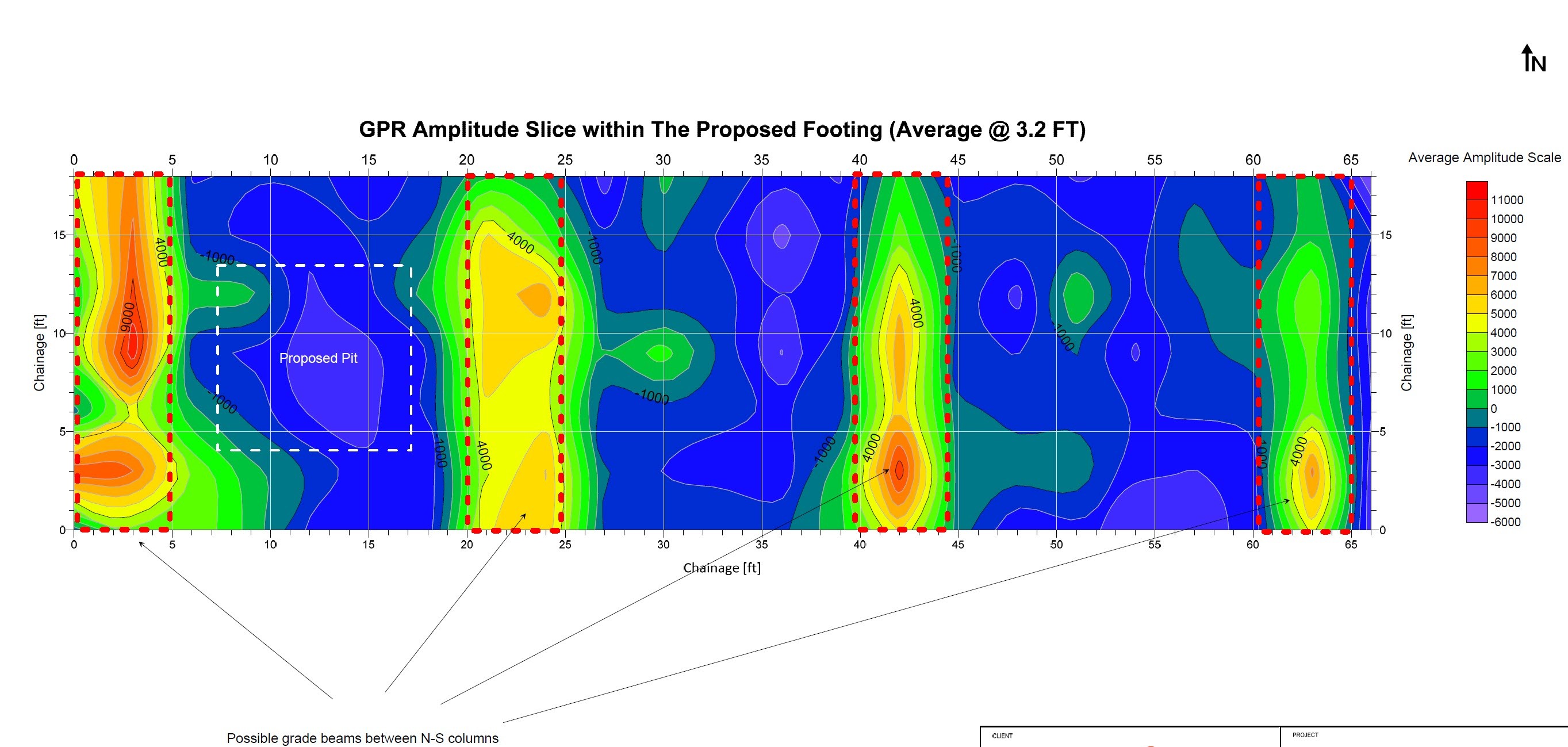
Scantec’s Utility Locating service helps engineers, contractors, and project owners precisely identify and mark the position of underground utilities before any excavation begins. By combining Ground Penetrating Radar (GPR) and electromagnetic detection technologies, we deliver clear and reliable data that minimizes risk, prevents costly damages, and ensures safer construction planning.
Our team operates under international SUE and safety standards, ensuring every utility—from power lines and telecom cables to water, gas, and drainage systems—is accurately mapped and.

01/
Accurate Detection
Identify underground utilities and structures with centimeter-level precision.
02/
Safe & Non-Destructive
Survey without digging, keeping the site safe and intact.
03/
Cost & Time Efficiency
Prevent damage, reduce delays, and optimize project planning.
What we use?
Scantec’s Utility Locating service helps engineers, contractors, and project owners precisely identify and mark the position of underground utilities before any excavation begins. By combining Ground Penetrating Radar (GPR) and electromagnetic detection technologies, we deliver clear and reliable data that minimizes risk, prevents costly damages, and ensures safer construction planning.
Our team operates under international SUE and safety standards, ensuring every utility—from power lines and telecom cables to water, gas, and drainage systems—is accurately mapped and documented.
Typical workflow
EM locating.
Use GPR to fill the gaps
Confirm suspected routes
Find non-metallic lines
Check crossings / depth change areas
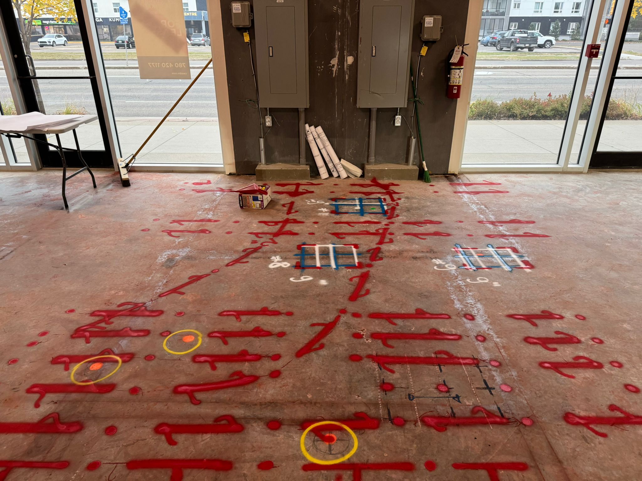
Mark and map
Paint marks + flags on surface
Tie into site control (RTK/total station) for an as-built sketch
Quality checks
Multiple GPR passes (different directions)
Compare EM vs GPR where both are available
Frequency choice
Lower frequency (e.g., 200–400 MHz): deeper, less detail
Mid (e.g., 400–900 MHz): good balance for many outdoor locates
High (e.g., 1–2+ GHz): shallow + high detail (better for concrete scanning than deep utilities)


Why choose Scantec?
Innovation
We embrace new ideas and foster creativity to empower growth and forward-thinking solutions.
Collaboration
Shared energy and diverse minds create stronger outcomes—we thrive when we work together.
Dedication
Our commitment to excellence drives us to consistently deliver value to our community.

STEP 1
Site Assessment
We begin by reviewing project details, blueprints, and ground conditions to determine the best scanning method for your site.
STEP 2
GPR Scanning
Using advanced Ground Penetrating Radar (GPR) and electromagnetic (EM) tools, our technicians scan and record underground data with high accuracy.
STEP 3
Data Interpretation
All collected data is analyzed by trained specialists to identify utilities, rebar, voids, or other subsurface structures.
STEP 4
Reporting & Marking
We deliver clear, visual reports and on-site markings to help you plan safely and proceed with confidence.